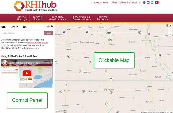
The Am I Rural? screen has two sections, the control panel on the left and a clickable map on the right.

Enter a full or partial address in the address line of the Control Panel. The more specific an address match you can find, the more accurate your report will be. For simplicity, the examples used here are for towns. However, a street address would be preferred if you are seeking results for a specific facility or location.
After you have entered your address, click the Locate button or press the Enter key.

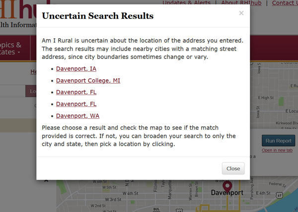
If there are multiple potential matching locations, a pop-up will display the options. Select the best match and confirm on the map.

To find your location, you can zoom and move within the map. On desktop, use the +/- controls in the upper right of the map section to zoom. On mobile, you can use the pinch-to-zoom gesture; the +/- controls are not available. Click and hold on the map while moving your mouse to change the map area displayed.
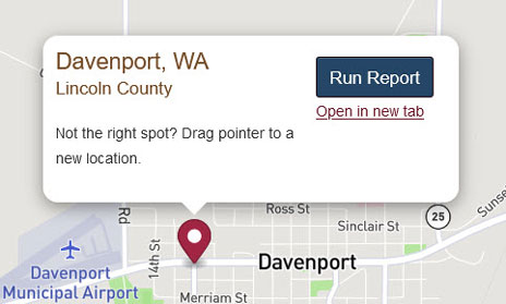
Click on the map to place a new marker on the map at that location. The address associated with that location is added to the list of addresses (see Step 2). You can drag-and-drop a map marker to a new location or click the map in a new spot to add an additional address.
You can also allow the Am I Rural? tool to find your current location using the “Find my location” icon in the upper right of the map.
Am I Rural? results within the same census tract will be the same. Sometimes moving your location just a small distance can make a difference in the rural status. This information could be helpful if you don’t already have a fixed location for your program. In the lower right, select to display the census tract. Some locations have the same tract for 2010 and 2020, while in other locations you will have to pick which year you prefer. The map will display the area covered by the census tract where your point is located. You can pick a point in a different census tract to see how the results vary. There is also an option to turn off the location information, if it is blocking your view of the census tract borders.
Note that this feature is not available on mobile.
One or more addresses will be displayed as search results. If there are two or more results, one will be highlighted/selected, and the map will be zoomed to a marker at that point. You can click another address in this list to switch to that location.

As you enter addresses or click on the map, your address list will continue to grow, listing up to the most recent 20 addresses. You can remove an address by clicking the “X” to its right. Clicking “Clear All” will empty your address list.
After you have selected an address, click the Run Report button in the map section.

A report will be displayed for the selected location:

When you enter an address, the Am I Rural? tool uses Bing's geocoding web service to retrieve one or more possible matches for the entered address. These found addresses are added to your address list as options. You can then choose the best match. Along with detailed address information, the geocoder returns the latitude/longitude coordinates of each address. Am I Rural? uses these coordinates to place a marker on the map when you click on a found address.
When you click on the map or drag an existing location marker, Am I Rural? uses Bing's reverse geocoding web service to find possible matches for that location's geospatial coordinates. The found addresses are added to your address list.
Occasionally, clicking on a detailed street-level view of the map will result in reverse geocoding results that aren't for a specific building but rather for a street or ZIP code. Even though an address may not be at the detail level you prefer, the rural classification report is always run against the marker's exact geolocation. Therefore, the report results will reflect the status at the current marker location, not the address listed.
See RHIhub’s What is Rural? topic guide for more information on how rural is defined and why there are different definitions in use.
The rural classification report contains the following sections:
Information on the current location is shown here, including:
The information provided by this service addresses only the rural aspect of a program's requirements. Your Am I Rural? report is not a guarantee of your rural status. Please check with the program contacts directly to verify your eligibility for specific federal programs.
See RHIhub’s What is Rural? topic guide for more information on how rural is defined and why there are different definitions in use.
Information on the location's rurality, based on seven common rural definitions:
The Office of Management and Budget (OMB) defines two types of Core Based Statistical Areas (CBSAs):
Metropolitan statistical areas have a population of 50,000 or more
Micropolitan statistical areas have a population of 10,000 or more but less than 50,000
Each area consists of one or more counties containing the core urban area, along with adjacent counties that are tied to the urban area via commuting. Areas outside of CBSAs are nonmetropolitan (rural).
Current CBSAs are defined based on the most recent U.S. Census Bureau population estimates. For more information, see Metropolitan and Micropolitan Statistical Areas Main.
Am I Rural? reports if a location is in a metropolitan or micropolitan area and what the name of the area is. If the location is not in a CBSA, the location is identified as nonmetropolitan.
Data Source: 2023 TIGER/Line, U.S. Census Bureau
The U.S. Census Bureau defines an urban area for the 2020 Census as a densely settled core of census blocks with at least 2,000 housing units or a population of at least 5,000. Areas outside of urban areas are not classified by this definition and are generally considered rural.
Am I Rural? reports if a location is or is not in an urban area.
The Am I Rural? tool can help determine if a location is considered rural by the Federal Office of Rural Health Policy (FORHP). FORHP offers many grant programs to help rural communities improve the health of their residents. To be eligible for these programs, the applicant organization must be located in an FORHP-defined rural area.
Counties that are nonmetropolitan or micropolitan (that is, not metropolitan) are considered rural by FORHP. Within metropolitan counties, FORHP identifies additional census tracts as rural based on Rural Urban Community Area code and population density. For more information on how these tracts are selected, see the Federal Office of Rural Health Policy section of Defining the Rural Population.
Data Source: County and census tract list provided by the Federal Office of Rural Health Policy
Frontier and Remote Area (FAR) codes are a collaboration of the USDA Economic Research Service and the Federal Office of Rural Health Policy. FAR areas are defined in relation to the time it takes to travel by car to the edges of nearby Urban Areas (UAs) and Urban Clusters (UCs). FAR codes are assigned at the ZIP code-level using 2010 ZIP codes, based on a combination of population size and travel time. There are four FAR levels, with Level 4 being the most remote.
The Am I Rural? tool reports the FAR code for the ZIP code of a given location.
Rural Urban Commuting Area (RUCA) codes are a collaboration of the USDA Economic Research Service and the Federal Office of Rural Health Policy. This definition uses daily commuting patterns to understand a location's rurality.
RUCA codes are assigned at the census tract and zip-code level based on population density, urbanization, and daily commuting patterns. The primary classification uses 10 codes (1-10) to identify metropolitan, micropolitan, small town, and rural commuting areas, based on the primary flow of commuting. Secondary commuting flow is used to subdivide these 10 codes.
Current RUCA codes by census tract are based on data from the 2010 Census and the 2006-10 American Community Survey. On July 3, 2019, the USDA revised the Rural-Urban Commuting Area (RUCA) Codes data product to correct a programming error affecting the 2010 secondary RUCA codes. The revision corrects the secondary codes of 10,909 of 74,002 census tracts. Secondary RUCA codes may be used to classify census tracts into rural and urban categories. The revised secondary codes result in an increase in the number of census tracts classified as rural. The 2010 primary RUCA codes are not affected by this revision.
The Am I Rural? tool reports the RUCA code for the census tract of a given location.
Rural Urban Continuum Codes (RUCCs) are assigned at the county-level by the USDA Economic Research Service. RUCCs are numeric, 1-9. Codes 1-3 are assigned to metro counties based on population. Codes 4-9 identify different types of rural counties based on degree of urbanization and adjacency to metro counties.
The Am I Rural? tool reports the RUCC for a given location's county.
Urban Influence Codes (UICs) are assigned at the county-level by the USDA Economic Research Service. UICs are numeric, 1-12. Codes 1 and 2 are assigned to metro counties based on population. Codes 3-12 identify different types of rural counties based on micropolitan or noncore status and adjacency to more populous counties.
The Am I Rural? tool reports the UIC for a given location's county.
The U.S. Census Bureau identifies geographic areas as urban or rural, based on population density. For more information, see County-level Urban and Rural information for the 2020 Census.
Using population data from the 2020 Census, Am I Rural? reports the percent of a county's population that is rural.
Data Source: U.S. Census Bureau
Identifies whether the location is eligible for the following based on rural location:
The Am I Rural? tool can help determine if a location is considered rural by the Federal Office of Rural Health Policy (FORHP). FORHP offers many grant programs to help rural communities improve the health of their residents. To be eligible for these programs, the applicant organization must be located in an FORHP-defined rural area.
Counties that are nonmetropolitan or micropolitan (that is, not metropolitan) are considered rural by FORHP. Within metropolitan counties, FORHP identifies additional census tracts as rural based on Rural Urban Community Area code and population density. For more information on how these tracts are selected, see the Federal Office of Rural Health Policy section of Defining the Rural Population.
All locations in American Samoa, Guam, Federated States of Micronesia, Marshall Islands, Northern Mariana Islands, Palau, Virgin Islands, and the U.S. Minor Islands are eligible for FORHP grants.
Data Source: County and census tract list provided by the Federal Office of Rural Health Policy
RHC geographic eligibility is defined by statute to be an area that is not an urbanized area as designated by the Census Bureau. As of 2020, the Census Bureau is no longer designating urbanized areas. CMS interim guidance considers a location to meet the rural location requirement for the RHC program if it is outside of an urbanized area in the 2010 Census Bureau data OR if it is outside of a urban area in the 2020 Census Bureau data.
Health Professional Shortage Areas (HPSAs) are designated by the Health Resources and Services Administration's Office of Shortage Designation, based on requests from state Primary Care Offices (PCOs). There are three types of HPSAs: primary care, dental, and mental health. A HPSA may be a geographic area, population group, or health care facility that has a shortage of health professionals, based on criteria that include population-to-clinician ratios. HPSAs can be located in urban and rural areas.
Am I Rural? identifies any current HPSA designations for the location.
Medically Underserved Areas/Populations (MUAs/MUPs) are designated by the Health Resources and Services Administration's Office of Shortage Designation. MUAs/MUPs may also be designated by a state's Governor.
Medically Underserved Areas (MUAs) are geographic areas where there is a shortage of health services. Medically Underserved Populations (MUPs) are groups of people with economic, cultural, or linguistic barriers to healthcare. The factors that influence an MUA/MUP designation include primary care physician-to-population ratio, infant mortality rate, poverty, and elderly population.
Am I Rural? finds both federally designated and Governor's exception MUAs/MUPs for a given location.
The Am I Rural? service can be used to help determine whether a specific location is considered rural based on various definitions of rural, including definitions that are used as eligibility criteria for federal programs. The information provided by this service addresses only the rural aspect of a program's requirements. Your "Am I Rural?" report is not a guarantee of your eligibility status. Please check with the program contacts directly to verify your eligibility for specific federal programs.